Mostrando entradas con la etiqueta Geografía. Mostrar todas las entradas

viernes, 18 de junio de 2010

¿Cuáles son los grandes Parques Nacionales del mundo?

Fuente:

http://blogs.libertaddigital.com/articulos-de-viaje/cuales-son-los-grandes-parques-nacionales-del-mundo-6573/

Información:

¿Cuáles son los grandes Parques Nacionales del mundo?

18 de Junio de 2010 - 13:26:09 - Carmelo Jordá

Recibí hace unos días un correo de Tripadvisor con una lista de Parques Nacionales de todo el mundo recomendados por sus usuarios, rápidamente me pareció un tema interesante que trasladarles, queridos lectores, con los mejores Parques del mundo, pero me he encontrado que, pese a lo que yo esperaba, parece ser que decidir una lista de esos lugares de todo el planeta en los que disfrutar de la naturaleza es más complicado de lo que parece...

Pese a ello, vamos a ponernos a la tarea, tirando de algunas fuentes y, espero, de sus opiniones: todos conocemos algún lugar especial que al menos para nosotros merece estar en un top ten de grandes espacios naturales, así que anímense a hacer sus aportaciones en los comentarios.

Una primera referencia que podemos usar es un listado aparecido en la web National Parks Traveler, en el que pese a prometer un top ten se quedaba en un listado de sólo cinco. Éstos eran el Friordland, en Nueva Zelanda, un país cuya naturaleza se ha puesto muy de moda tras los rodajes de las películas de El señor de los anillos; el Kruger sudafricano era el segundo; el tercero uno también muy conocido: el de Tikal en Guatemala, que además de naturaleza nos ofrece impresionantes restos arqueológicos mayas; el cuarto Kaieteur, en la Guyana; y el quinto Machu Picchu, en Perú, otro lugar en el que la arqueología es tan o más importante que la naturaleza.


Los lectores de esta web americana, habitualmente centrada en los propios Parques Nacionales de los Estados Unidos, hacen algunas aportaciones interesantes como las Galápagos, los Parques Nacionales de Canadá como Banff o incluso de lugares de Europa como el Wadden Sea, la franja costera que comparten Holanda, Alemania y Dinamarca.

Por todo el mundo

Jaunted, una web sobre viajes y turismo realmente interesante y con un contenido muy amplio nos ofrece una selección de 13 Parques Nacionales que además sitúa sobre el mapa, en el que aparecen algunos de los que ya hemos comentado como las Islas Galápagos y también clásicos como el famoso Parque de Yellowstone, probablemente el más conocido del mundo y desde luego con no poca razón: no sólo es un lugar maravilloso sino que fue el primero de todos, ya allí nació el propio concepto nada más y nada menos que en 1872.

También en los Estados Unidos desde Jaunted nos proponen otro Parque, también presente en la lista de Tripadvisor que les comentaba al principio, y que es bastante menos conocido: Zion, que pese a su más bien hebreo nombre está en el estado de Utah y es, sin duda, un lugar con una naturaleza rocosa absolutamente maravillosa.
Y para terminar con el listado estadounidense, no puedo dejar de citar Yosemite, que además de ser otro de los más conocidos y visitados de América, y de ser Patrimonio de la Humanidad, tuvo la suerte de ser uno de los lugares recurrentes en los que se paseó con su cámara Ansel Adams(bueno, teniendo en cuenta que usaba enormes trastos de gran formato no sé si a eso se puede llamar a eso pasear), quizá el mejor fotógrafo de paisajes de la historia.


Imagen del usuario de Flickr David

Más opiniones: en el prestigioso The Times británico Simon Barnes, por lo que veo un buen especialista en vida salvaje, nos revelaba su propia lista de preferencias basada en algo tan válido como subjetivo: su propio gusto personal. En primer lugar, un Parque africano, South Luangwa, en Zambia; y en segundo uno indio, Kaziranga. También incluye algunos europeos como el esloveno Lvysoke Tatry, el británico Lake District y, bingo, nuestro Coto de Doñana.

De libro

En Timeless Earth nos proponen una lista más larga, de nada más y nada menos que 100 Parques Nacionales distribuidos por los cinco continentes. No sé si en el contenido, pero al menos en el planteamiento se parece mucho al de este libro que se puede adquirir por módico precio en Amazon y seguro que queda estupendo sobre la mesa del comedor.

Al ser la lista tan larga incluye prácticamente todos los comentados y muchos más, entre ellos algunos clásicos como el Torres del Paine chileno, el famosísimo Ayers Rock australiano o el africano Masai Mara, uno de esos nombres que siempre vienen a nuestra mente cuando pensamos en vida salvaje.


Imagen del usuario de Flickr Paul Mannix

Otra particularidad de este listado es que permite la aparición de algunos lugares de Japón y China, por ejemplo el japonés Monte Fuji, quizá la montaña más fotografiada del planeta, o Zhangjiajie, una fastuosa región montañesa en el gigante asiático.

En el correo de Tripadvisor del que ha nacido todo esto, por cierto, hay un buen número de sugerencias, algunas de las que ya hemos hablado y otras bastante originales y con un aspecto muy interesante como Bryce Canyon en EEUU; Cinque Terre, en Italia; el Samaria Gorge en Creta; el Glenveagh National Park and Castle irlandés, Dilek en Turquía y Koli en Finlandia, la verdad es que es una selección de lo más variada e interesante.

¿Y en España?

En nuestro país también tenemos una colección importante de Parques Nacionales, aunque nos incorporamos a la fórmula relativamente tarde, en 1916 se hizo una ley que definía el concepto y en 1918 se declararon los dos primeros: Covadonga y Ordesa.

El más conocido sin duda, y de hecho aparece en alguna de las listas que hemos comentado, es el Coto de Doñana, que en algunas ocasiones ha sido citado como el más importante de toda Europa. Personalmente no lo conozco, pero es uno de esos lugares a los que sin duda tengo ganas de ir como también lo es el Teide, el segundo de nuestros parques en el gran listado de 100 del que estamos hablando.

En el norte de España la densidad es quizá algo mayor gracias a las cadenas montañosas cantábrica y pirenaica. En la primera está el de los Picos de Europa, que guarda en su interior el original y pionero de Covadonga y es sin duda uno de los lugares más hermosos de España.

Y no puedo dejar de citar Timanfaya, uno de los lugares que más me ha impresionado en toda mi vida y que me parece de los sitios más notables y de imprescindible visita de toda España. Aunque en cierto sentido no sea lo que mucha gente espere de un Parque Nacional, la belleza del paisaje es absolutamente sobrecogedora.


Dicho todo esto, que no ha sido poco, ¿cuáles son sus Parques Nacionales preferidos en España? ¿Y en el mundo?

miércoles, 28 de octubre de 2009

CÁDIZ, MISTERIOS DE MAR Y TIERRA

Fuente:

http://www.akasico.com/noticia/1666/Geograf%C3%ADa-m%C3%A1gica/cadiz-misterios-mar-tierra.html

Información:
Geografía mágica

Historias y leyendas de una ciudad milenaria

Última actualización 26/05/2008@14:32:27 GMT+1

La Gadir fenicia, la Gades latina, la Cádiz conocida por todos, plaza estratégica para mercaderes y piratas, encierra tantas historias curiosas, imposibles y asombrosas como años, más de 3.000, tienen sus piedras. Este somero recorrido nos introduce en el templo de Baal Hammón y baja a los túneles subterráneos, asiste al milagro del maremoto de 1755, escucha el estruendo de la explosión de 1947 e intenta bucear en el enigmático cráter de la Bahía.

Por José Manuel Serrano Cueto
¿Te ha parecido interesante esta noticia? Si (1) No(0)

Noticias Relacionadas

domingo, 25 de octubre de 2009

Welcome to Vinlanda: The Vinland Map on the Web.

Fuente:

http://www.isidore-of-seville.com/vinland/

Información:

Welcome to Vinlanda: The Vinland Map on the Web.

This page explores the controversy surrounding the so called "Vinland Map," assembling some 100 pages on the topic from every corner of the web. Here you will find serious scholars pro and con as well as a bevy of quacks—all categorized and described. I've added a certain amount of material on the other, less dubious, sources for Viking activity in North America—the sagas and archaeological excavations at L'Anse aux Meadows, Newfoundland—and some general links on Scandinavian history.

A lot has happened in the last few months, including new analyses of the parchment and ink. The debate resembles a tennis match more every day. Check out the Recent Developments section. Your help finding new material, and your comments, are most welcome.

A Brief Introduction to The Vinland Map

The Vinland Map purports to be a 15th century map depicting Viking exploration of North America centuries before Columbus. If genuine, the Vinland map is one of the great documents of Western civilization; if fake, it's an astonishingly clever forgery.

Since its announcement and publication in 1965 the Vinland Map has been in and out of favor. The initial publication, Skelton et al. The Vinland Map and Tartar Relation, trumpeted its authenticity. Then, in 1972, a scientific team headed by Dr. Walter McCrone reported that its ink contained anatase, a form of titanium which first appeared in ink during the 1920s. Twenty years later, in 1992, Dr. Thomas Cahill of UC Davis found anatase in a variety of medieval manuscripts and the question was reopened. In 1995 Yale released a second edition of the book, together with further articles in support of the map, even as scholarly opinion outside of Yale increasingly turned against it. Most recently, two studies, one on the parchment and another on the ink, seemed to many to point in different directions. The last word? Don't bet on it.

Questions, site suggestions and comments can be sent to editor@isidore-of-seville.com.

I hope you enjoy the site,

Tim Spalding
Brookline, MA (USA)

jueves, 20 de agosto de 2009

Update on Research on Cayce's Three Hall of Records

Fuente:

http://www.edgarcayce.org/_AncientMysteriesTemp/hallofrecordsupd.html

Información:


Update on Research on Cayce's Three Hall of Records

Cayce’s Three Atlantean Halls of Record were located in Egypt near the Sphinx, underwater in the Bimini area, and in the Yucatan area possibly near the ancient Maya city of Piedras Negras (Spanish for Black Rocks) in Guatemala. The latter location was not specifically named in the readings, but from clues and details given in several readings, researchers in the 1930s determined Piedras Negras to be the correct location. The Cayce readings state that the records were saved prior to the final destruction of Atlantis around 10,500 B.C. Stone tablets, linens, gold, and other artifacts are stored in the Halls. The records relate the entire history of humanity including the beginnings “when the Spirit took form or began the encasements” in physical bodies in the ancient lands of Mu and Atlantis. They also contain information about the ancient practice of building pyramids. An update on the status of each follows:

Egypt - The Giza Plateau

In Egypt, A.R.E. members Joe Jahoda and Dr. Joseph Schor have been unable to obtain permission to do further additional radar analysis of the 25 x 40 foot underground cavern that they discovered near the Sphinx in 1997. NASA scientists verified the cavern and Jahoda and Schor were allowed to do limited drilling in order to drop cameras down for a better look. Although the cavity appeared to be a natural formation, it made what may be an unnatural, 90-degree turn. Tentative approval was given for a more sophisticated radar analysis to be done in 1999. Due to a bureaucratic snafu, the permits were not approved. In a July 2001 article on the web site of the National Geographic Society, Zahi Hawass, Director General of the Giza Plateau, is said to have recently “urged other archaeologists to join him in a two year moratorium on all excavations in the area from Giza to Aswan.” The only explanation given is Hawass’ concern for the preservation of the existing monuments.

During the summer of 2001, two French archaeologists claimed to have located entrances to hidden chambers in the Great Pyramid of Khufu. Their discoveries were reported in an ABC Online News Service. The French researchers used computerized architectural data from Egyptian funeral designs as well as a technique called macrophotography to analyze hundreds of meters of walls within the pyramid. Although the two men are calling for a joint French-Egyptian effort to uncover the chambers, the response from other Egyptologists, both French and Egyptian, has been less enthusiastic. Zahi Hawass has responded emphatically that he is unaware of any evidence for hidden chambers or cavities in the Great Pyramid.

The National Geographic Society’s follow-up study of the so-called “door” found at the far end an air shaft leading from the Queen’s chamber in the Great Pyramid was due to commence in March of 2000. It has been repeatedly postponed with no reason given. This pyramid has just recently been reopened to the public. It was closed over the past year for repairs as part of a routine rotation and cleaning schedule involving all the pyramids at Giza. Given the great amount of publicity surrounding the airshaft door, the lack of follow-up is mysterious in itself. (The shafts have since been probed with more mysterious doors found.)

In 2004, Zahi Hawass announced that the University of Birmingham (UK) was performing an extensive ground-penetrating radar study of the area between the Sphinx and Great Pyramid to find the tunnels and chambers there. Hawass also related that the tunnel under the Sphinx had not been fully cleared of debris.

Yucatan Hall of Records - Piedras Negras

After 4 seasons of exploration at the ancient Maya site of Piedras Negras, Brigham Young University archaeologists have decided not to return. Instead, they plan to take the materials they have excavated over previous seasons and study them in the laboratory. The project was originally slated to last 5 years and no definitive reason is given for the decision to retreat to the laboratory. However, in the most recent report, Stephen Houston and Hector Escobedo hint at the “taxing” nature of the site itself. Located deep within the Guatemala jungle, Piedras Negras can only be accessed by 2-days of travel via rugged mountain “roads” then by canoe over white water rapids. Because the site is located in a rainforest, it is only feasible to work there in the dry seasons — roughly March through June. Even then, the weather is hot and humid and the remoteness of the site requires the most primitive camping conditions. The remoteness and primitive conditions combined with the nearby camps of several guerilla groups have helped to protect the site from widespread looting.

During the final season (Spring 2000), BYU focused efforts into probing some of the oldest pyramids located at the site. One of these appears to have a sublevel built during the PreClassic Maya era — around 400-600 B.C. Due to the unstable nature of the building materials, they were unable to completely penetrate to the core of the building. This portion of the site (South Group) and the Acropolis area are the most likely locations for the Hall of Records according to clues given by Cayce in the readings. Additional excavations were performed during 2000 within the Acropolis and, as in the past, were hampered by large piles of debris left at the site by the University of Pennsylvania’s digs in the 1930s.

The most outstanding find of the season was a 3000 lb. carved stone panel, which had been attached to a large pyramid. It was apparently thrown down the steps at some point in the distant past landing upside down in front of the Acropolis complex. It is the most complete hieroglyphic text uncovered at the site in 65 years. Although some of the carvings are eroded, archaeologists skilled in interpreting the hieroglyphs have determined that it contains the life story of Piedras Negras’ Ruler 2. This ruler was of the Turtle Clan and was named after the founding Father god of the Maya, Itzamna. Although the panel was carved well after the 10,000 B.C. Hall of Records period (it is dated to around 600 A.D), it does contain a reference to the Maya sacred creation date for the “Fourth World” (3114 B.C.) linking some of the events of the life of Ruler 2 to that time frame. Given that the Ruler also carries the name of Itzamna, there may be more to the purpose of the panel than the archaeologists are able to determine at this time. The study of Maya hieroglyphics is still in its infancy and even now it is understood that their writing style was very sophisticated and carried multiple levels of meaning.

Although abandoning their effort for the moment, BYU concedes that there is still much that is not understood about the site and that more excavation needs to be done. Given that the Guatemala government has utilized American funded projects such as this to help rebuild these sites and prepare them for tourist contact, chances are there will be future activity at Piedras Negras. This has already happened as the University of Pennsylvania has now announced that they will perfom site investigations at Piedras Negras in 2004. In addition, Greg and Lora Little will be making an expedition to Piedras Negras in 2004 to make a video documentary.

Bimini

Much exploration has been done in the area of the Bimini Islands since the discovery of the so-called Bimini Road in 1968. The Cayce readings had predicted the discovery of ruins in that area during that year. According to the readings, Bimini was near the place where the largest Atlantean island sank around 10,000 B.C. Since the discovery of the “road,” aerial photographic surveys have turned up several other unusual underwater formations. Some of these are pentagon-shaped and others resemble building foundations. Shipwreck debris scattered all over the area has confused the issue bringing some less than scientific and greatly sensationalized claims of “proof of Atlantis.” These claims are easily debunked and ridiculed by the scientific community.

Sampling of the stone found in the road formation has also turned up conflicting evidence. Samples taken in the 1970s by the U.S. Geological Survey concluded that the road was simply a natural beach rock formation. In 1997 Dr. Joan Hanley of the Gaea Project reported that the content of the rocks varied geologically to the point that they could not have been located side by side naturally. One of the most exiting discoveries, however, was a series of effigy sand mounds shaped like a shark, dolphin and alligator within the Bimini mangrove swamps. The mounds align primarily with the stars Sirius, Rigel, Vega, and Capella in about A.D. 1000. Ground penetrating radar has failed to locate any artifacts under the mounds although the high water table may have created a barrier.

The 1990s also brought the discovery of an additional large stone formation south of Bimini similar to the road found in 1968. Project Alta, a side-scan sonar search of the area south of Bimini, reported in 1993 the discovery of a 35-foot wide hexagonal feature as well as some unusual right angles, concentric circles, and triangular-shaped features. In 1998 and 1999 donations were received by the Gaea Project to do sonar analysis on the ocean floor near the location of the Bimini road off the Bahama ridge. Other investigations have since been done looking for possible ruins near the Gulf Stream, but results have been inconclusive.

Recent Investigations

In 2002 the ARE and the EFC funded a satellite imaging project of 630 sq km around Bimini. The imaging found over a dozen mysterious circles just to the south of Bimini. In 2003, Greg and Lora Little examined several of these circles and found that they are natural or of recent origin and not worthy of more investigation. In addition, the discovery of the underwater platform at Andros and a nearby area with what appear to be paving stones may have some connection to the Hall of Records.

In 2003, the Littles also performed several expeditions to Andros to investigate enigmatic underwater structures first spotted from the air in 1968 and 1969. Links to these reports can be found here. One of the most intriguing discoveries at Andros was unexpected. A gigantic three-tiered stone platform was found in shallow water off the coast. In April 2003, the ARE released a press release on this find.


HOME


Thule (ESP) - Wikipedia

Fuente:

http://es.wikipedia.org/wiki/Thule

Información:

Thule

De Wikipedia, la enciclopedia libre

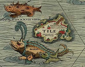
Thule como Tile en la Carta Marina de Magnus.

Thule o Tile (Θούλη, Tuli o Tyle) es un término usado en las fuentes clásicas para referirse a un lugar, generalmente una isla, en el norte lejano, a menudo Escandinavia.

«Última Thule» en la geografía romana y medieval puede también denotar cualquier lugar distante situado más allá de las «fronteras del mundo conocido».

Contenido

[ocultar]

Localización [editar]

Fue mencionada por primera vez por el geógrafo y explorador griego Piteas de Massalia (actual Marsella) en el siglo IV a. C. Piteas dijo que Thule era el país más septentrional, seis días al norte de la isla de Gran Bretaña, y que el sol de pleno verano nunca se ponía allí.

Para Procopio de Cesarea, Thule era una isla grande del norte habitada por 25 tribus. Se trata con toda probabilidad de Escandinavia, pues varias tribus son fácilmente identificables, tal como los gautas (Gautoi) y los saami (Scrithiphini). Éste escribió también que al volver los hérulos, pasaron con los varni y los daneses cruzando el mar a Thule, donde se asentaron junto con los gautas.

A veces se ha especulado con la conexión entre Thule y el mítico continente perdido de la Atlántida. La ubicación más probable de Thule se considera actualmente que pudiera ser la costa de Noruega — un estudio del año 2007 realizado sobre el mapa de Claudio Ptolomeo por un equipo de investigadores de la TUB (Universidad Técnica de Berlín) dirigido por Eberhard Knobhel, Dieter Legelmann y Frank Neitzel, identifica Thule con la isla actualmente llamada Smøla, ubicada frente a la ciudad de Trondheim y sede de la realeza tribal escandinava hacia el siglo I; otros historiadores piensan que se trata de las islas Shetland, las Feroe, Islandia o Groenlandia.

En la Edad media, el nombre se utilizó a veces para denotar a Islandia, por ejemplo en la Gesta Hammaburgensis ecclesiae pontificum, de Adán de Bremen, por los obispos de la Iglesia de Hamburgo, donde se citan probablemente escritos más antiguos acerca de Thule.

Místicos nazis buscaron por todo el mundo la Thule histórica, que ellos creyeron era la patria primigenia de la «raza aria». La organización esotérica alemana que más influenció al nazismo se llamaba la Sociedad Thule.

Uso moderno del término Thule [editar]

Thule es el nombre de una base polar fundada en Groenlandia por Knud Rasmussen en 1910 al norte de la bahía de Baffin, que llegó a ser un municipio de la Groenlandia gobernada por Dinamarca. Los thule, una cultura paleo-esquimal antecesora de los inuit groenlandeses modernos, denominaron Thule a la región. En 1953, en el contexto de la Guerra Fría, la Thule groenlandesa llegó a ser la base aérea de Thule, operada por la Fuerza Aérea de Estados Unidos como avanzada estratégica ante la URSS. La población nativa fue forzada a restablecerse en Qaanaaq, 108 kilómetros al norte. Las actividades de caza realizadas allí se describen en el National Geographic de enero de 2006. (76°31′50″N 68°42′36″O / 76.53056, -68.71 a sólo 840 millas náuticas del Polo Norte).

La llamada «Tule meridional» o «Tule del Sur» es una colección de tres islas en el extremo sur de las Islas Sandwich del Sur en el Océano Atlántico. Una de ellas lleva el nombre de Thule (Morrell), siendo sus coordenadas 59°27′S 27°11′O / -59.45, -27.183. Este grupo de islas son territorios reclamados por la República Argentina. Fueron anexionados por Gran Bretaña —junto a las islas Malvinas, las Georgias del Sur y las restantes Sandwich del Sur—, en 1833. Tule del Sur es un territorio inhabitado.

Adaptación [editar]

Destacable es la aparición de Thule en la lingüística élfica quenya creada por J. R. R. Tolkien para su épica literaria, en la cual figura como representación de la combinación fonética de la th, utilizada también en la escritura tengwar de los elfos, igualmente creada por Tolkien; además de tener un significado en lo que es el lenguaje por si misma, siendo el significado de Thule 'espíritu'.

Véase también [editar]

Enlaces externos [editar]

Thule (ING) - Wikipedia

Fuente:

http://en.wikipedia.org/wiki/Thule

Información:

Thule · Mythology

From Wikipedia, the free encyclopedia

Jump to: navigation, search
Thule as Tile on the Carta Marina of 1539 by Olaus Magnus, where it is shown located to the north west of the Orkney Islands, with a "monster, seen in 1537", a whale ("balena"), and an orca nearby.

Thule (pronounced /ˈθuːli/, us dict: thōō′·lē; Greek Θούλη, Thoulē; also spelled in various sources Thile, Tile, Tilla, Toolee, Tylen, Thula, Thyle, Thylee, Thila, Thulii, Thyilea, Tula, and Tila) is, in classical literature, a place, usually an island. Ancient European descriptions and maps locate it either in the far north, often Iceland,[1] possibly the Orkney Islands or Shetland Islands or Scandinavia, or in the Late Middle Ages and Renaissance Iceland or Greenland. Another suggested location is Saaremaa in the Baltic Sea.[2]

Ultima Thule in medieval geographies may also denote any distant place located beyond the "borders of the known world." Some people use Ultima Thule as the Latin name for Greenland when Thule is used for Iceland.

Contents

[hide]

[edit] Ancient geography

The Greek explorer Pytheas is the first to have written of Thule, doing so in his now lost work, On the Ocean, after his travels between 330 BC and 320 BC] He supposedly was sent out by the Greek city of Massalia to see where their trade-goods were coming from.[3] Descriptions of some of his discoveries have survived in the works of later, often skeptical, authors. Polybius in his Histories (c. 140 BC), Book XXXIV, cites Pytheas as one "who has led many people into error by saying that he traversed the whole of Britain on foot, giving the island a circumference of forty thousand stades, and telling us also about Thule, those regions in which there was no longer any proper land nor sea nor air, but a sort of mixture of all three of the consistency of a jellyfish in which one can neither walk nor sail, holding everything together, so to speak."[4]

Strabo in his Geography (c. 30), Book I, Chapter 4, mentions Thule in describing Eratosthenes' calculation of "the breadth of the inhabited world" and notes that Pytheas says it "is a six days' sail north of Britain, and is near the frozen sea." But he then doubts this claim, writing that Pytheas has "been found, upon scrutiny, to be an arch falsifier, but the men who have seen Britain and Ierne (Ireland) do not mention Thule, though they speak of other islands, small ones, about Britain." Strabo adds the following in Book II, Chapter 5:

Now Pytheas of Massilia tells us that Thule, the most northerly of the Britannic Islands, is farthest north, and that there the circle of the summer tropic is the same as the Arctic Circle. But from the other writers I learn nothing on the subject—neither that there exists a certain island by the name of Thule, nor whether the northern regions are inhabitable up to the point where the summer tropic becomes the Arctic Circle.

Strabo ultimately concludes, in Book IV, Chapter 5, "Concerning Thule, our historical information is still more uncertain, on account of its outside position; for Thule, of all the countries that are named, is set farthest north."

Nearly a half century later, in 77, Pliny the Elder published his Natural History in which he also cites Pytheas' claim (in Book II, Chapter 75) that Thule is a six-day sail north of Britain. Then, when discussing the islands around Britain in Book IV, Chapter 16, he writes: "The farthest of all, which are known and spoke of, is Thule; in which there be no nights at all, as we have declared, about mid-summer, namely when the Sun passes through the sign Cancer; and contrariwise no days in mid-winter: and each of these times they suppose, do last six months, all day, or all night." Finally, in refining the island's location, he places it along the most northerly parallel of those he describes, writing in Book VI, Chapter 34,: "Last of all is the Scythian parallel, from the Rhiphean hills into Thule: wherein (as we said) it is day and night continually by turns (for six months)."

Other late classical writers and post-classical writers such as Orosius (384-420 A.D) and the Irish monk Dicuil (late 8th and early 9th century), describe Thule as being North and West of both Ireland and Britain. Dicuil described Thule as being beyond islands that seem to be the Faroes, strongly suggesting Iceland. In the writings of the historian Procopius, from the first half of the 6th century, Thule is a large island in the north inhabited by twenty-five tribes. It is believed that Procopius is really talking about a part of Scandinavia, since several tribes are easily identified, including the Geats (Gautoi) and the Saami (Scrithiphini). He also writes that when the Heruls returned, they passed the Varni and the Danes and then crossed the sea to Thule, where they settled beside the Geats.

[edit] Ancient literature

A novel in Greek by Antonius Diogenes entitled The Wonders Beyond Thule appeared c. AD 150 or earlier. Gerald N. Sandy, in the introduction to his translation of Photius' ninth-century summary of the work,[5] surmises that Thule was "probably Iceland."

Early in the fifth century AD Claudian, in his poem, On the Fourth Consulship of the Emperor Honorius, Book VIII, rhapsodizes on the conquests of the emperor Theodosius I, declaring that the "Orcades [Orkney Islands] ran red with Saxon slaughter; Thule was warm with the blood of Picts; ice-bound Hibernia [Ireland] wept for the heaps of slain Scots." This implies that Thule was Scotland. But in Against Rufinias, the Second Poem, Claudian writes of "Thule lying icebound beneath the pole-star."

Over time the known world came to be viewed as bounded in the east by India and in the west by Thule, as expressed in the Consolation of Philosophy (c. AD 524) by Boethius.

For though the earth, as far as India's shore, tremble before the laws you give, though Thule bow to your service on earth's farthest bounds, yet if thou canst not drive away black cares, if thou canst not put to flight complaints, then is no true power thine.[6]

The Roman historian Tacitus, in his book chronicling the life of his father-in-law, Agricola, describes how the Romans knew that Britain (which Agricola was commander of) was an Island. He writes of a Roman ship that circumnavigated Britain, and discovered the Orkney Islands and says the ship's crew even sighted Thule. However their orders were not to explore there, as winter was at hand.

[edit] Middle Ages to Nineteenth Century

During the Middle Ages the name was used first of all to denote as Iceland, such as by Dicuil, by the British monk Venerable Bede in De ratione temporum, by the Landnámabók, by the anonymous Historia Norwegie and by the German bishop Bremen's Deeds of Bishops of the Hamburg Church, where they cite ancient writers' usage of Thule but also new knowledge since the end of antiquity. All these authors also understood that other islands were situated in the north of Britain.

A madrigal by Thomas Weelkes entitled Thule from 1600, describes it thus:

Thule, the period of cosmography,
Doth vaunt of Hecla, whose sulphureous fire
Doth melt the frozen clime and thaw the sky;
Trinacrian Etna's flames ascend not higher...[7]

Thule is referred to in Goethe's poem "Der König in Thule" (1774), famously set to music by Franz Schubert (D 367, 1816), and in the collection Ultima Thule (1880) by Henry Wadsworth Longfellow.

Edgar Allan Poe's poem "Dream-Land" (1844) begins with the following stanza:

By a route obscure and lonely,
Haunted by ill angels only,
Where an Eidolon, named Night,
On a black throne reigns upright,
I have reached these lands but newly
From an ultimate dim Thule —
From a wild weird clime, that lieth, sublime,

Out of Space — out of Time.

[edit] Modern use

A municipality in northern Greenland (Avannaa) was formerly named Thule after the mythical place. The Thule People, a paleo-Eskimo culture and a predecessor of modern Inuit Greenlanders, were named after the Thule region. In 1953, Thule became Thule Air Base, operated by United States Air Force. The population was forced to resettle to Qaanaaq, 67 miles to the north[8] (76°31′50.21″N 68°42′36.13″W / 76.5306139°N 68.7100361°W / 76.5306139; -68.7100361 only 840 NM from the North Pole). Southern Thule is a collection of the three southernmost islands in the South Sandwich Islands in the South Atlantic Ocean. The island group is overseas territory of the United Kingdom and uninhabited.

The Scottish Gaelic for Iceland is "Innis Tile", which means literally the "Isle of Thule".[9] Ultima Thule was the title of the 1929 novel by Henry Handel Richardson, set in colonial Australia. Thule lends its name to the 69th element in the periodic table, Thulium.

Ultima Thule is also the name of a location in the Mammoth Cave system. It was formerly the terminus of the known-explorable southeastern (upstream) end of the passage called "Main Cave," before discoveries made in 1908 by Ed Bishop and Max Kaemper showed an area accessible beyond it, now the location of the Violet City Entrance. The Violet City Lantern tour offered at the cave passes through Ultima Thule near the conclusion of the route.

[edit] Aryan Thule

Nazi mystics believed in a historical Thule/Hyperborea as the ancient origin of the Aryan race. Much of this fascination was due to rumours surrounding the Oera Linda Book "found" by Cornelis Over de Linden during the 19th Century. The Oera Linda Book was translated into German in 1933 and was favored by Heinrich Himmler. The book has since been thoroughly discredited.

The Traditionalist School expositor Rene Guenon believed in the existence of ancient Thule on "initiatic grounds alone". According to its emblem, the Thule Society was founded in 1919. It had close links to the Deutsche Arbeiter Partei (DAP), later the Nationalsozialistische Deutsche Arbeiterpartei (NSDAP, the Nazi party). One of its three founding members was Lanz von Liebenfels (1874–1954). In his biography of Liebenfels ("Der Mann, der Hitler die Ideen gab", Munich 1985), the Viennese psychologist and author Dr Wilhelm Dahm wrote: "The Thule Gesellschaft name originated from mythical Thule, a Nordic equivalent of the vanished culture of Atlantis. A race of giant supermen lived in Thule, linked into the Cosmos through magical powers. They had psychic and technological energies far exceeding the technical achievements of the 20th century. This knowledge was to be put to use to save the Fatherland and create a new race of Nordic Aryan Atlanteans. A new Messiah would come forward to lead the people to this goal." In his book "Mit ruhig festem Schritt" (1998), a history of the SA, Wilfred von Oven, Joseph Goebbels' Press adjutant from 1943 to 1945, confirmed that Pytheas' Thule was the historical Thule for the Thule Gesellschaft.

[edit] See also

[edit] References

  1. ^ Bostock & Riley (1893) page 352 (on "Chapter 30 (16) – Britannia") assert: "Opinions as to the identity of ancient Thule have been numerous in the extreme." The notes on Book IV of Pliny in an an 1829 translation into French by Ajasson de Grandsagne mention six, which are taken word-for-word in translation by Bostock & Riley (their words in quotes): ―
    • "That Thule is the island of Iceland." Burton (1875) pages 1, 25.
    • "That it is either the Ferroe Group, or one of those islands." Burton pages 22-23.
    • "The notion of Ortelius, Farnaby, and Schœnning, that it is identical with Thylemark in Norway." Burton page 25.
    • "The opinion of Malte Brun, that the continental portion of Denmark is meant thereby, a part of which is to the present day called Thy or Thyland." Fotheringham (1862) page 497.
    • "The opinion of Rudbeck and of Calstron, borrowed originally from Procopius, that this is a general name for the whole of Scandinavia." Grandsagne (1829) page 338: "L'idée de Rudbeck ... et de Calstron ... due originairement à Procope, qui ... a prononcé nettement que sous ce nom était comprise toute la Scandinavie." The reference is to Procopius Book III No. 4.
    • "That of Gosselin, who thinks that under this name Mainland, the principal of the Shetland Islands, is meant. The reference to "Gosselin" or elsewhere "M. Gosselin" and his monumental work dating from the time of the French Revolution is much copied even though miscited. No such geographer existed; the "M." must stand for Monsieur. The Library of Congress catalog cites the work as: Gossellin, Pascal François Joseph ([1798]-1813.). Recherches sur la géographie systématique et positive anciens; pour servir de base à l'histoire de la géographie ancienne. Paris: L'imprimerie de la république [etc.] an VI. http://lccn.loc.gov/02007793. This four-volume work is rare and inaccessible today. The opinion is said to come from Volume I page 162 under the title Thulé.
    Bostock and Riley continue: "It is by no means impossible that under the name of Thule two or more of these localities may have been meant, by different authors writing at distant periods and under different states of geographical knowledge. It is also pretty generally acknowledged, as Parisot remarks, that the Thule mentioned by Ptolemy is identical with Thylemark in Norway."
  2. ^ "The reflections on the Kaali meteorite in ancient legends"
  3. ^ L. Sprague de Camp (1954). Lost Continents, p. 57.
  4. ^ Polybius. Book XXXIV
  5. ^ B. P. Reardon, ed. (1989). Collected Ancient Greek Novels. Berkeley, Los Angeles, London: University of California Press. ISBN 0-520-04306-5.
  6. ^ Irwin Edman, ed.; W. V. Cooper, translator (1943). The Consolation of Philosophy. New York: The Modern Library, Random House.
  7. ^ RPO -Thomas Weelkes : Thule, the Period of Cosmography
  8. ^ Gilberg (1976) page 86. Hunting activities here are described in the January 2006 National Geographic.
  9. ^ Rannsaich an Stòr-dàta Briathrachais Gàidhlig

[edit] Bibliography

  • Burton, Richard F. (1875). Ultima Thule: Or, A Summer in Iceland. London, Edinburgh: W.P. Nimmo. Downloadable Google Books.
  • Fotheringham, W.H. (Sessions 1857-8 – 1859-60 published in 1862). "On the Thule of the Ancients" (pdf). Proceedings of the Society of Antiquaries of Scotland (Neill and Company for the Society, online by the Archaeological Data Service) III: 491-503. http://archaeologydataservice.ac.uk/catalogue/adsdata/PSAS_2002/pdf/vol_003/3_491_503.pdf. Retrieved on 2008-11-01.
  • Gilberg, Rolf (June 1976). "Thule" (pfd). Arctic (Arctic Institute of North America) 29 (2): 83–86. http://pubs.aina.ucalgary.ca/arctic/Arctic29-2-83.pdf. Retrieved on 2008-10-30.
  • Pliny; Ajasson de Grandsagne (Translator) (1829) (in French). Histoire naturelle de Pline: Traduction Nouvelle: Vol III. Paris: C.L.F. Panckoucke. pp. 337–338, notes on Book IV.
  • Pliny; John Bostock; Henry Thomas Riley (Translators) (1893). The Natural History of Pliny: Volume I. London, New York: George Bell & Sons. pp. 352, notes on Book IV.

[edit] Films

martes, 4 de agosto de 2009

Clases sociales en la India - No Solo Viajeros

Fuente:

http://www.nosoloviajeros.com/clases-sociales-en-la-india/

Información:

Clases sociales en la India

Agosto 6, 2008 | por Jon Sainz | 6,928 views

Castas en la India

La India es una gran nación, de ello no hay duda, miles de años de historia y tradiciones lo confirman. El problema surge cuando algunas de estas tradiciones, aunque sobre el papel extintas, se mantienen vigentes; me refiero a las castas.

Las castas son las clases sociales en las que esta dividida la sociedad India, la pertenencia a una u a otra depende de la familia en la que se nazca. Teoricamente desde 1952 este sistema discriminatorio esta prohibido, pero la realidad es bien diferente.

Existen cuatro castas, que de mayor a menos pureza son las siguientes:

  • Brahmanes: son los sacerdotes encargados de interpretar y enseñar los textos sagrados.
  • Kshatriyas: son guerreros y gobernantes encargados de defender su sociedad.
  • Vaishyas: son artesanos y comerciantes, encargados de alimentar a la sociedad.
  • Sudras: campesinos y gente trabajadora, cuya única labor es servir a las demás castas.

Por debajo de estas 4 castas están los intocables, a quienes no se les incluye en el sistema de castas, son personas consideradas impuras desde su nacimiento. Representan un 25% de la población India (más de 160 millones) y hacen los trabajos sucios que los demás no quieren hacer, como: limpieza de letrinas, incineración de cadáveres, limpieza de pozos sépticos, trabajos que implican un contacto físico con sangre , excrementos…

Los intocables suelen ser en demasiadas ocasiones víctimas de violaciones, linchamientos o asesinatos por miembros de castas superiores.

Lo oficial es que toda la sociedad India es igual ante la ley y ante el prójimo, la realidad es esta:

  • Cerca del 90% de las personas pobres y el 95% de las personas analfabetas son intocables.
  • Unos cuarenta millones de personas son intocables. De esos cuarenta millones 15 son niños y niñas que trabajan por un salario mínimo.
  • La mitad de los niños y el 64% de las niñas no pueden acabar la escuela porque son humillados por sus profesores /as.

Fuente y mayor información | Wikipedia

lunes, 27 de julio de 2009

Fantasy Name Generator By Samuel Stoddard - Version 1.4

Se trata de un generador online, basado en una base de datos muy completa con palabras y nombres históricos. Interesante.

Enlace:

http://rinkworks.com/namegen/

miércoles, 22 de julio de 2009

Real Fantasy Cities

Fuente:


Información:

Real Fantasy Cities

It is easy to forget that there are places in our world that are as fantastic as anywhere in a fantasy world. Popa Taungkalat is one such place.

hilltop

In could be home to Tolkienesque king or the lair of some fiendish creature - imagine a dragon standing proud and erect on the edge, ready to leap off. In reality it is a monastery with 777 steps leading up to it. What secret wisdom could a party of adventures discover here?